
By Bailee Fenton and Meghan Dasilva.

In 2020, we completed the Great Divide Trail (GDT), an 1100 km long-distance trail that threads along the continental divide through the Canadian Rocky Mountains. The GDT is known to be a challenging trail, sometimes overgrown and even missing at times, but the payoff is well worth it. The views are nothing short of spectacular, we both have yet to hike a long-distance trail that compares. The trail offers several alternate routes, some following rugged, remote paths with significant elevation gains and losses. Due to unpredictable weather, we mostly stuck to the GDT proper, but we knew we would eventually return to explore these alternate routes.
In Section E, from Jasper to North Saskatchewan River, Banff, we learned of the six passes route, a trail-less high route that bypasses the overgrown Magline Valley on the official GDT. The weather window was not in our favour then, but four years later we decided to tackle it. The route traverses six passes along the southern part of the Magline Mountain Range, ending after the 16 km rugged ridge known as Endless Chain Ridge. On a clear day it offers stunning alpine views. However, as of 2022, Parks Canada reported that the ecological integrity of the area was at risk. To protect the habitat and reduce human-wildlife conflicts, especially with grizzly bears, the route was closed to random overnight camping1. This means anyone attempting the route would need to complete it in a single day.
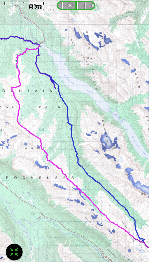
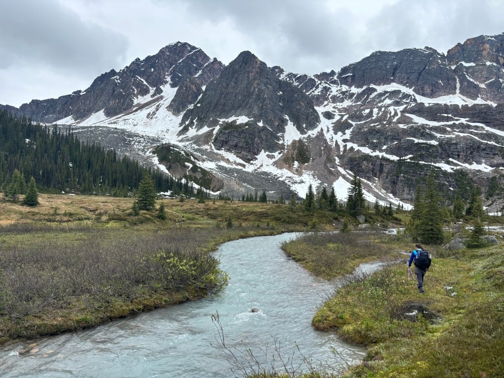
We chose the route for an early season adventure. Just days before our start date, GDT hikers that had passed the route warned that it would likely be covered in snow. However, we had aligned our schedules for an early July attempt and a challenging adventure appealed to us. We planned to hike the route southbound, just as we had with the GDT, starting at Maligne Lake and finishing at Highway 93 via the Poboktan Creek Access Trail.

On July 3rd, we left the Maligne Lake parking lot and were hiking on the Bald Hills trail at 5:30 a.m. By 8 a.m., we had left the established trail and stepped into the unknown. It was a misty, overcast morning, with clouds drifting lazily through the valley. As we ascended, we entered a world veiled in fog, with scattered patches of lingering snow, a reminder of how stubbornly winter clings to the Canadian Rockies.
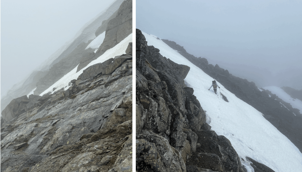
We hit our first obstacle just before 10 a.m., a giant cornice stretching along the summit’s north side. We managed to navigate around it by crossing a steep snow patch and scrambling up the peak. The sense of accomplishment was bittersweet, as we stood enclosed in fog, with no idea what lay ahead. As Mother Nature began to snow on us—oh, early July in the Canadian Rockies—we weighed the risks of continuing. We could only anticipate more cornices and the possibility of post-holing through snowfields between passes. The thought of scrambling down and retracing our steps across the snow patch was unappealing. So, we decided to push on, figuring we would attempt the route as long as it remained manageable and we felt safe. The day was young, and there was a chance that summer might lie beyond the next pass.


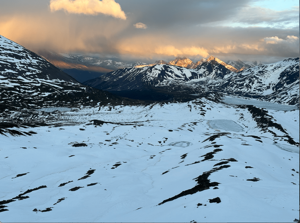
Our wishful thinking seemed to pay off. As we descended the first pass, which felt more like a ridge, the fog started to lift, and we were greeted with grand views of the Maligne Range and glacier-fed lakes. As we navigated south through the rocky alpine, it was fairly obvious to us where we were headed. The next climb had some snow, but from a distance, we could plan a route with little effort. We ascended the next pass via a gradual grassy climb, easily avoiding snow patches. The following two passes were similar and straightforward, with slight variations in steepness. One pass involved navigating a boulder field on the descent. Each pass offered stunning views from the top, a lush valley below, and creeks that flowed from the Maligne range into the Maligne River. The open terrain and weather allowed us to spot the next pass and choose a route that would minimize our exposure to snow.


All day, we parallelled the Maligne Mountain Range, which towered on our right as we traversed the route. At the top of the fourth pass, we could see the next pass was covered in a blanket of snow, there was no option of a dry route. We had no ice axes or microspikes, but we were making great time and decided to get to the base before making a decision. It turned out to be a mellow approach with hard-packed snow. As we began the ascent, the consistency of the snow began to change, with scattered post-holing, but it did not slow us down too much.

At the top of the second to last pass, we could see the final pass illuminated by snow in the distance. It sat at the end of a very long but snow-free meadow, with a cold stream crossing; there had been several cold crossings along the route. So far, our journey had unfolded smoothly given the conditions. We had successfully navigated every snowy obstacle we encountered, and as we set our sights on the final ascent, we could only hope it would welcome us with the same measure of fortune.

By 8 p.m., we had crossed the meadow and found ourselves navigating through knee-to waist-high snow. After begging the sun all day to come out all day, it finally did. Then a rainbow popped up across the pass, as if pointing the way to the treasure—the end of the route. After an exhausting day of navigating and constantly gaining and losing elevation, it felt like everything was leading up to this moment— the final pass. We were so close. The sun, the rainbow, we just needed to get over to the next valley. We joked that summer was hiding on the other side of this pass, with thawed lakes and flowers blooming in the lush meadow. We thought we would soak in the sunset as we set up camp and enjoy a summer evening.

Just before reaching the pass, we paused to look back at the panorama views of the mountains we had traversed by. It was one of those ‘you had to be there’ kind of beautiful. We admired the blanket of snow we had navigated, its surface now glistening in the sunlight. We welcomed the warmth on our skin. Out here, the silence was striking—a calm stillness that made the world feel both expansive and close. We couldn’t help but feel a deep sense of gratitude—not just for the privilege of experiencing these wild places, but for the friendship that allows us to share them.

When we reached the top of the pass, the excitement quickly faded. There was no summer, and the ‘gold’ at the end of the rainbow was an unstable cornice. Beyond the final pass stretched a snowfield as far as we could see. It was 9 p.m., and turning around was unrealistic, we’d be hiking all night through sensitive grizzly habitat, yikes.
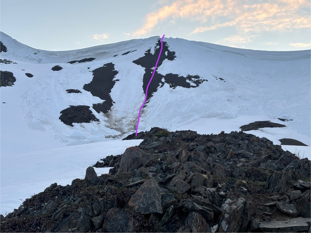
We assessed the cornice and weighed our options, carefully walking along the side of the cornice in search for some magical exit. Lucky for us, the cornice had broken off in an area just large enough for us to slide through. It was extremely steep and sketchy descending the pass through a small avalanche path, but we were incredibly grateful to have had a route down.
We made our way down moving quickly and avoiding the overhead hazard as best as we could. Once we reached the bottom of descent, we found ourselves slogging through the softest snow of the day. Post-holing with nearly every step; sometimes reaching water beneath. We post-holed across the valley until 11 p.m., finally setting up camp on a small snow-free patch near the GDT.
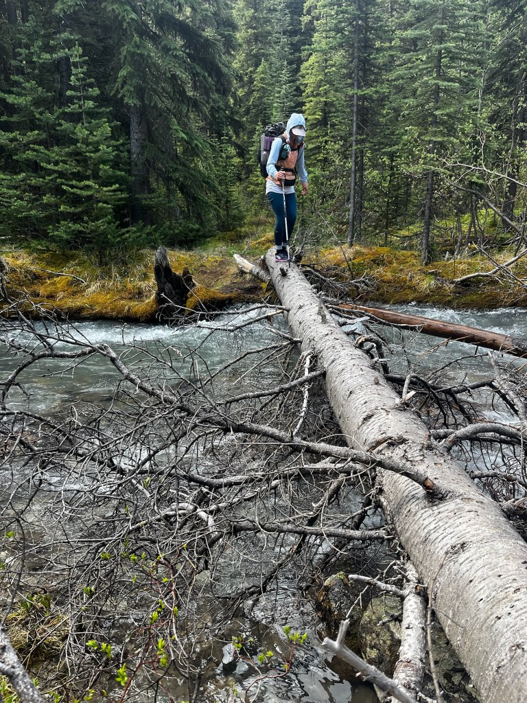
The next morning, we woke up excited to be back on the established GDT—a snow-free dirt path. After only one day, we felt the relief of a dry trail, despite the multiple raging river crossings. Thankfully, safe log crossings were provided when needed, and we were soon on the Poboktan Creek Access Trail, cruising the final ~6 km to the car.
The goods:
Day 1: Magline Parking lot to GDT (~.5km away)
Distance: 37.5 km
Elevation Gain/Loss: +2538m / -1892 m
Total Time: ~15 hours
Day 2: GDT to Poboktan Creek Access Trail
Distance: 17.3 km
Elevation Gain/Loss: +19m / -782m
Total Time: ~6 hours
Follow more adventures at:
Bailee Fenton – Squirt: @westcoastgirl_xo on Instagram or the web at https://rootedinthewild.blog/
Meghan Dasilva – Baby Hulk: @dasilva.meg on Instagram or the web at http://www.happyhikingtrails.com/blog
Disclaimer:
Please reach out to baileefenton90@gmail.com to access the GPX tracks.
The tracks were recorded using the Gaia GPS app. While they provide a general reference, we cannot guarantee the accuracy or reliability of the data. Use them at your discretion.
References:

Leave a comment