
By Bailee Fenton and Meghan Dasilva.
On September 9th, 2020, after 36 days of hiking along the Continental Divide we touched the southern terminus of the Great Divide Trail (GDT). The trail had taken us through the rugged Canadian Rockies, weaving in between Alberta and British Columbia. That summer was unseasonably cold and wet, which spared us from the threat of wildfires, but it meant we spent many days struggling to stay warm. The trail often kept us at high elevation, leaving us constantly at the mercy of the weather. It didn’t take long to realize the mountains held all the power.
Hiking the GDT presented us with enough challenges on its own, and with the added factor of weather windows, high routes were generally out of the question. On September 7th, we entered Section A— the final stretch for us as southbound hikers—and we were caught in a snowstorm. Earlier in the hike, in Section F, we faced rain that turned to snow as we ascended further into the alpine, leading to a close call with hypothermia. We weren’t about to repeat that experience. Instead, we opted to take a lower route, missing out on hiking the famous La Coulotte Peak. But we swore one day, we’d be back to conquer it. After all, can you truly say you hiked the GDT if you haven’t summited La Coulotte?

At 5 a.m. on August 24, 2023, our alarm forced us awake. For a brief moment, we lingered in our cozy full loft sleeping bags, in the quiet hostel room. Appreciating the moment as we had just spent four days hiking in Glacier National Park in Montana, where we had been saturated by rain. However, now, in the southern Canadian Rockies, we hoped to be graced with a beautiful, dry summer day. We left Castle Mountain Resort in the dark, buzzing with excitement—this was a bucket list hike for us. Stumbling north on the GDT, which at that point was actually Highway 774, we brushed our teeth as the world was waking up. The morning was calm and peaceful. We spotted a moose grazing on grass as we ate one of our forever favourite breakfasts; cheese buns.
We had decided since we were tackling La Coulotte, we might as well add Barnaby Ridge to make it a loop—and naturally, we’d do it southbound. Both Barnaby Ridge and La Coulotte lie within Castle Wildland Provincial Park, a park established in February 2017 that allows backcountry camping without permits1. Managed by Alberta Parks, the park is bordered by private land and grazing leases. If you look on a map, you’ll see La Coulotte straddles the park boundary.

We quickly reached the Southfork trailhead, the northern access point for the Barnaby Ridge alternate. The trail began as a wide, manicured gravel path, so well maintained that it made us question if we were even on the right trail. We continued on as the path turned into a single-track dirt trail leading to Barnaby Lake. Not long after, we reached Southfork Lakes; the last on trail water source for the Barnaby Ridge Alternate.

The path faded away as we continued southbound on Barnaby ridge. It felt like the beginning of a roller coaster ride; the slow, gradual incline seemed to stretch on forever. Our excitement level was high as we climbed toward Southfork Peak and then Amoeba Peak. We did not summit Amoeba, but instead followed a game trail that skirted around the peak. Soon after, we hit Barnaby Ridge Peak, taking in the views of Castle Mountain ski hill to our west.

It was a beautiful summer morning, and we were grateful to finally be hiking this route. The purple argillite rocks reminded us we were not far from Glacier National Park, yet the weather made it feel entirely different. Glacier National Park and Castle Wildland Provincial Park are part of the Belt-Purcell Supergroup, resulting in similar mountain formations and rock compositions2 3.

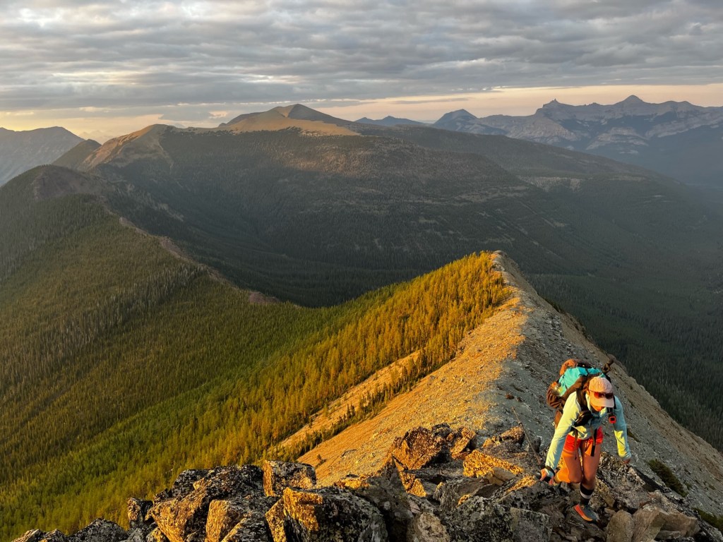
The day had been going smoothly. The ridge was relatively wide and flat until we reached the crux. When hiking this ridge southbound, the route to bypass the scramble section is easy to miss—or maybe we just hadn’t looked closely enough. The terrain quickly shifted from a welcoming wide ridge to a narrow, rocky one and eventually became a full on, ‘spicy’ scramble. We stopped, unsure if we were still on the right path. After a brief chat, we decided to backtrack about 10 meters and attempt to descend the ridge, aiming to walk along the east side where the terrain looked to be flat enough and avoid the scramble.However, we quickly found ourselves cliffed out. In the chaos, Meghan lost a hiking pole while trying to avoid tumbling down. Unsure of where to go next, and before we had time to assess, a voice suddenly called out ‘ARE YOU OKAY?’ We looked down to see a fellow hiker below, who suggested walking a little bit further along the ledge and then climbing up, might lead to a possible route down. Grateful for his advice and vantage point, we decided to give it a try. We wished him good luck as he continued on, searching for a route up farther north, hopefully less sketchy than ours.

We scrambled down the narrow rocky ridge and started cruising along the east side of the ridge. Other than the scramble, navigating was fairly easy as we rode the ridge, but water needs to be considered— it is an exposed route for the most part. There are only two sources on the entire ridge; one involves a very steep, off route descent down to Grizzly Lake. After a little forest bushwhacking—nothing challenging—we finally saw Grizzly Lake from the ridge. We found a path down through the stunted forest—a good trail that eventually faded into the loose gravel—but we were able to easily navigate to the lake. It was around 4 p.m., and we took a well-deserved break, enjoyed a swim in the lake, and then headed back up. For perspective, you lose about 100 metres in elevation in a very short distance of about 200 metres. The steep descent was well worth it for some cold, fresh alpine water.

After Grizzly Lake, we catch a glimpse of Ruby Lake; there’s no visible access from Barnaby Ridge—unless you have a parachute. From there, we floated along the ridge, absorbing the views.

After passing Ruby Lake lying far below, the trees on the west side stretch to the ridgeline, forcing you to hug the edge. The forest lining the top of the ridge creates a trail-like effect. At one point, there was a short, tricky scramble with some chains—thanks Dan! At 7:45 p.m., we reached the summit block for the final push to La Coulotte. Tired, but still buzzing with excitement, we made our way up the final scramble sections, which were equipped with chains.

At 8 p.m., we reached La Coulotte Summit, just in time for sunset. We were instantly hit with a wave of joy and washed with relief as we took in the moment. Exhausted, but exhilarated by the day’s adventure. The sky burned with hues of orange and yellow, casting silhouettes of the rugged peaks. We stood in awe, grateful for the chance to witness this magical moment.
Now back on the official GDT, we began our descent until we found a flat spot for camp tucked in the trees. We enjoyed one of our favourite dinners— cold soak peanut butter ramen. As we watched the sun disappear beyond the mountains, the wind picked up, and the air became cool, our cue to get into our cozy dry sleeping bags.

This day was what hiking dreams are made of for us. The perfect weather, endless views, mountain lake swims—a day spent on Barnaby ridge had it all. It was the adventure we were craving. At times, the route felt like peak bagging, while at other times, we cruised along ridges through alpine forests, across goat trails, and out in the open.

The next morning, we started hiking at 6 a.m., surrounded by thick fog with the sun struggling to fight through. We enjoyed cruisy ups and downs before starting the continuous descent to Sage Pass, then to the Castle Mountain Ski Resort Trail, and finally to Range Road 40A.
The goods:
Day 1: Castle Mountain Resort to Ridge Camp on La Coulotte Descent
Distance: ~29 km
Elevation Gain/Loss: +2280m / -1413m
Time Hiking: ~11 hours
Day 2: Ridge Camp on La Coulotte Descent to Castle Mountain Resort
Distance: ~20 km
Elevation Gain/Loss: +313m / -1097m
Time Hiking: ~6 hours
Follow more adventures at:
Bailee Fenton – Squirt: @westcoastgirl_xo on Instagram or the web at https://rootedinthewild.blog/
Meghan Dasilva – Baby Hulk: @dasilva.meg on Instagram or the web at http://www.happyhikingtrails.com/blog
Disclaimer:
Please reach out to baileefenton90@gmail.com to access the GPX tracks.
The tracks were recorded using the Gaia GPS app. While they provide a general reference, we cannot guarantee the accuracy or reliability of the data. Use them at your discretion.
References:

Leave a comment